Phase I has been completed as of Feb. 27, 2026. Phase II work will begin fall 2026.
OC Public Works will perform pedestrian bridge improvements within the Wilderness Area at Mason Regional Park, east of Culver Drive. This work will help reduce flooding and improve public safety in this area.
Trail closures are necessary to complete this important work and maintain public safety.
WHAT:
Crews are installing eight (8) pedestrian bridges in two phases throughout the Wilderness Area at the locations shown above.
Phase I will include six (6) bridges. Phase II will include work on the remaining two (2) bridges once Phase I is complete.
Trail closures are necessary near the work areas to accommodate these important trail improvements.
Pedestrians can use open, available trails connecting Rockview to University Dr. at Goldenglow St. and University Dr. at Yale Ave. during Phase I.
Sidewalks along Culver Dr. and University Dr. are also available to bypass the work areas.
Intermittent closures may occur along the open areas to allow for passing construction vehicles.
Your safety is our top priority! This is an active construction area. Please observe all trail closure signs, barriers, flaggers and project vehicles moving in and out of the work area.
WHEN:
Anticipated Construction Duration: Fall 2025 — Spring 2026
Working Days/Hours: Monday - Friday, 7 a.m. - 4 p.m.
Trail closures in effect at all times. The construction schedule is tentative and subject to change due to weather and other factors.
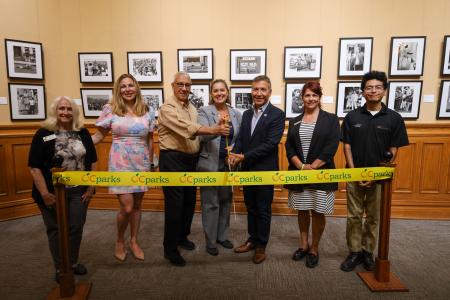
The Other Side of Memory Exhibit Ribbon Cutting.jpg
Body
(Santa Ana, Calif.) – Step into the compelling photographic experience at The Other Side of Memory: Photographs by Luis C. Garza exhibit now on display at the Old Orange County Courthouse in Santa Ana (211 W. Santa Ana Blvd.). With striking visuals of historic moments of activism and community from the 1960s and ‘70s, the nationally touring exhibition features rare black-and-white images drawn from Garza’s archive, many of which are on public view for the first time.
The captivating images in this exhibit document powerful defining moments of activism that took place on both coasts and abroad, including the Chicano civil rights movement in Los Angeles, Young Lords Party protests and feminist marches in New York and global gatherings such as the World Peace Conference in Budapest. Printed as silver gelatin fiber prints, the photographs reflect a personal visual record of resistance, identity and collective memory.
“We are very fortunate to display this special and rare collection of photos depicting pivotal historic moments for our community at the Historic Orange County Courthouse,” said Vicente Sarmiento, Orange County Board of Supervisors. “The images featured in The Other Side of Memory (El Otro Lado de La Memoria) document the significance of the Chicano civil rights movement in Southern California and beyond, capturing the spirit of activism and shedding light on the untold stories of these events.”
Garza became an indispensable chronicler of the Chicano movement for La Raza magazine, capturing intimate and unsparing moments of resistance, identity and community with uncommon immediacy. Today, his photographs can be found in major museum collections such as The Cheech Marin Center for Chicano Art & Culture, Crystal Bridges Museum of American Art, Sala de Arte Público Siqueiros (Mexico City) and The Autry Museum of the American West.
Admission to the exhibit is free and open to view at the Old Orange County Courthouse gallery Monday through Friday from 8 a.m. to 4:30 p.m. through the end of the year. Metered parking is available at the on-site lot and surrounding street parking. Additional parking is available at lot P8 (301 W. 5th Street). Parking fees apply.
OC Parks manages nearly 60,000 acres of parks, historical and coastal facilities and open space for the County of Orange as part of OC Community Resources. http://www.ocparks.com
Friday, August 29, 2025: OC Parks has received the results of the necropsies performed on three bass fish that died during the incident. Bacteriology, histology, parasitology, heavy metals and viral hemorrhagic septicemia virus (VHSV) were tested. The testing yielded the following results:
Bacteriology: No significant issues detected.
Histology: Results were normal and showed no cause for concern.
Parasitology: No notable parasitic presence identified.
Heavy Metals: Some elevated levels were detected (notably cadmium and arsenic), but not at concentrations high enough to explain the mortality of approximately 500 fish. It is important to note that heavy metals (such as mercury, cadmium, copper, etc.) tend to persist in tissues over time.
Viral hemorrhagic septicemia virus (VHSV): Not detected.
Following this incident, OC Parks is taking steps to have the necessary equipment and resources in place to be more prepared and respond quicker should anything like this occur in the future. Inspection protocols are being thoroughly reviewed to identify where improvements can be implemented to minimize downtime and prevent future equipment failures. This includes increasing the frequency of inspections for critical components like manifolds and aerators and creating a preventative maintenance schedule. Additionally, remote lake monitoring options are being explored which will give better insights into changing lake conditions, allowing for a more proactive response.
For additional information related to this incident, visit FAQs.
Friday, August 8, 2025: OC Parks has completed a thorough analysis and review of multiple water samples collected throughout Laguna Niguel Lake and Sulphur Creek. No substances of significant level of concern were detected and healthy water qualities were observed. The results further add to the hypothesis that the fish die off incident most likely occurred naturally due to changing weather conditions throughout July.
Water sampling sites in Laguna Niguel Lake and Sulphur Creek. Click to view image.
During the summer months, phytoplankton (microscopic photosynthesizing algae) naturally occur in larger numbers. These organisms may bloom into sizable populations in warm weather when there is prolonged sunlight and little cloud cover. When this happens, phytoplankton will photosynthesize during the day, which can increase concentrations of dissolved oxygen in water, critical for fish survival. After sunset, phytoplankton and other plants in the lake ecosystem consume oxygen, causing dissolved oxygen concentrations in the water to fall.
When there is heavy cloud cover during the day, there may not be enough sunlight to sustain the phytoplankton bloom. This can lead to lower dissolved oxygen levels or a crash in the phytoplankton population. The drastic change can deplete dissolved oxygen and threaten fish and other organisms in the lake.
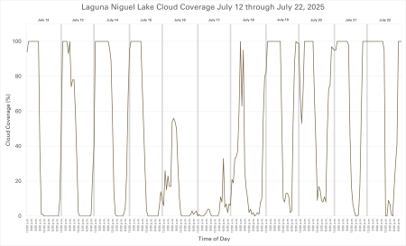
The graph belowshows July 2025 cloud cover data for Laguna Niguel. The data reveals little cloud cover in mid-July. The low cloud cover was immediately followed by high cloud cover for the next several days, ranging from 82% to 100% coverage. Experts believe this change likely reduced photosynthesis and dissolved oxygen production within the lake, causing this low oxygen event.While it is not believed to have had an effect on this incident, six aerators were also offline at the time, which could have impacted the conditions in the lake.
Laguna Niguel Lake cloud coverage July 12 – 22, 2025. Click to view image.
In these low oxygen conditions, fish in the lake likely would have sought areas with more oxygen, such as the incoming cooler water upstream in Sulphur Creek or near the Oxygen Saturation Technology Systems (OSTs) that were installed in the deep-water section of the lake in December 2024. Unfortunately, too many fish gathered in the creek at the location where the die off incident occurred. This could have been caused by a combination of factors including the shallow water depths in that area or insufficient dissolved oxygen for the number of fish that were in such a small area.
To ensure a thorough analysis of all possible factors that may have contributed to the die off incident, OC Parks worked closely with OC Public Works to collect water samples in three locations within Sulphur Creek, which is primarily fed by urban runoff. Samples were analyzed for nutrient content, water quality and several major classes of pesticides and metals. Healthy water quality levels were observed, and the findings concluded a toxic event likely did not cause the fish die off.
Water samples analyzed for ph levels, water temperature, nutrients and solids yielded results within normal range. View the full nutrients report.
Dinetofuran and thiamethoxam, two neonicotinoid pesticides, were detected in Sulphur Creek at levels far below scientific benchmarks from the U.S. Enviornmental Protection Agency (USEPA 2023)1 and published studies (Finnegan et al. 2017)2.
An herbicide, glyphosate, was detected in one of three water samples collected from the creek at a very low concentration, just above the method detection limit. This particular water sample was collected outside the boundaries of Laguna Niguel Regional Park at a concentration far below the lowest toxic concentration. View the full pesticides report.
OC Parks is awaiting the results of the necropsy. Once received, further information will be shared.
1 USEPA. 2023. Dinetofuran DRAFT Biological Evaluation: Effects determinations for federally listed endangered and threatened species and designated critical habitats. Environmental Fate and Effects Division, Office of Pesticide Programs, USEPA, Washington, DC.
2 Finnegan, M.C., L.R. Baxter, J.D Maul, M.L. Hanson, and P.F. Hoekstra. 2017. Comprehensive characterization of the acute and chronic toxicity of the neonicotinoid insecticide thiamethoxam to a suite of aquatic primary producers, invertebrates, and fish. Environ. Toxicol. Chem. 2017 Oct;36(10): 2838-2848.
Friday, August 1, 2025: A Town Hall meeting to discuss the fish die off will take place Saturday, August 9 from 10 a.m. to 12 p.m. at Laguna Niguel Regional Park. More information and register for the Town Hall.
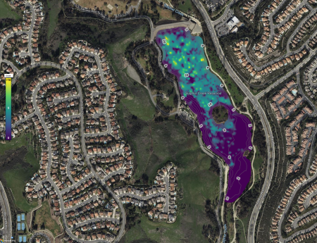
Wednesday, July 30, 2025: OC Parks has received the results of a hydroacoustic, sonar-based fish mapping survey throughout Laguna Niguel Lake. This high-tech method uses sound waves to assess fish population, distribution and habitat use in the lake. During the survey, sonar equipment emits sound waves into the water and records the echoes that return after bouncing off objects such as fish. The survey illustrates where fish are actively present within the lake and shows evidence of a healthy and sustained fish population.
As shown below, the map indicates the density and distribution of fish in Laguna Niguel Lake. The numbers and contour lines represent the approximate water depth, and the brightest color yellow represents the presence of 10 or more fish within the zone.
Mapping shows the highest population density of fish are concentrated in the north end of the lake where the water is deeper and cooler. This is also where two oxygen saturation systems (OST) are located, which saturate the water with dissolved oxygen and are most effective when used in deep water. Please note, hydroacoustic mapping software does not show fish populations in water less than 3 feet deep, therefore fish in the shallower, south end of the lake may not be represented on this map. However, this mapping does provide a comprehensive look at fish abundance and distribution throughout Laguna Niguel Lake.
Hydroacoustic mapping completed Monday, July 28, 2025. Click map to access the document.
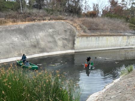
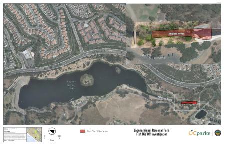
Friday, July 25, 2025: As of Thursday, July 24, all cleanup efforts from the recent fish die off within Sulphur Creek near the south end of Laguna Niguel Lake have concluded. Approximately 500 fish were affected, predominantly bass and bluegill, and there have been no reports of additional fish surfacing.
OC Parks continues to work closely with experts in the field to monitor the current conditions of the lake. Water samples from multiple locations and depths have been collected to test water quality, including temperature, dissolved oxygen (DO), pH, and conductivity (salinity). Hydroacoustic fish mapping is also being conducted to assess the remaining fish population in Laguna Niguel Lake.
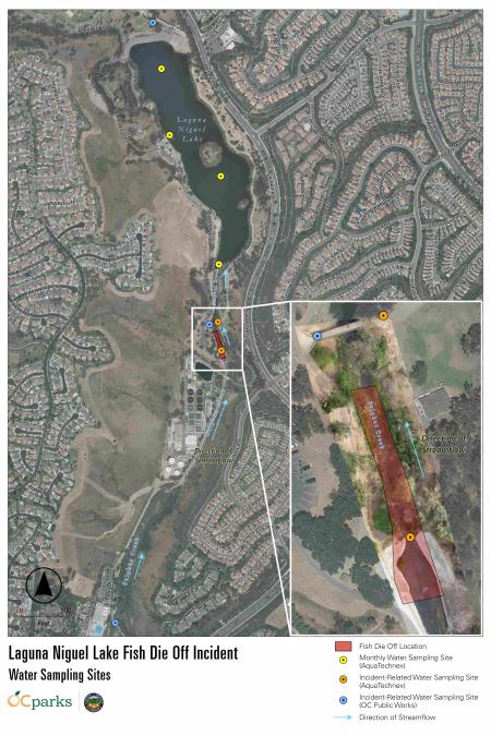
Location of fish die off within Laguna Niguel Regional Park. Click map to access the document.
Wednesday, July 23, 2025: OC Parks is saddened by the recent fish die off that occurred at Laguna Niguel Lake within Laguna Niguel Regional Park and have been working around the clock to address the situation. We understand the importance these lakes have for the community and want to stress that we are taking this very seriously.
While we cannot definitively say exactly what caused this to happen, as fish die offs can occur naturally from time to time, a combination of factors could have contributed to the situation such as changing weather, increase in water temperature, a lower than average rainfall year, the presence of algae and potential equipment malfunction.
As of now, it appears the fish die off was due to a change in weather causing the water temperature to increase, particularly in the shallow waters at the south end of the lake where most of the fish were seen on the surface. When this happens, there is less oxygen in the water, which is critical to fish survival. Catfish can tolerate the warmer, desert-like conditions present in Laguna Niguel Lake this time of year, but other fish are more affected, seemingly leading to this fish die off. While there is no way to control the water temperature of the lake, further steps are being taken that could possibly help mitigate this from occurring in the future.
OC Parks cares deeply about providing the necessary conditions for fish to survive and thrive in the lakes under our management. All equipment has been thoroughly checked to certify everything is functioning properly. Additionally, we are continuing to monitor water temperature and oxygen levels within the lake to ensure conditions remain stable.
As of Wednesday, July 23, most of the cleanup efforts have concluded, with only a handful of fish surfacing over the last 24 hours. When visiting Laguna Niguel Regional Park, should you ever encounter any wildlife in distress, please contact the park office at (949) 923-2240.
This project has been completed as of December 2025.
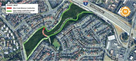
OC Public Works will perform stabilization improvements along a portion of the Aliso Creek Bikeway to address potential erosion and ensure effective flood protection.
WHERE:
Aliso Creek Bikeway between the I-5 (San Diego Freeway) and Paseo de Valencia.
WHAT:
A portion of the Aliso Creek Bikeway will be closed intermittently during construction.
Crews will install rock “rip-rap” bank protection and grade stabilization in multiple areas along the Aliso Creek Bikeway. Rip-rap are large rocks placed to minimize erosion.
Residents living in close proximity to the flood channel will experience a temporary increase in noise and dust during working hours.
A portion of the bikeway will be closed intermittently during construction. Signage will be present and detours will be implemented.
There may be brief delays or stops for the public along the trail for vehicles and equipment entering the work area. Flag personnel will be on site to guide people through the area.
Drivers will have full access to all surrounding roads, yet may experience brief delays at times during certain project activities.
WHEN:
Anticipated Construction Duration: Phase I: July - September 2025 Phase II: September - December 2025
Working Days/Hours: Monday - Friday, 7 a.m. - 5 p.m.
The construction schedule is tentative and subject to change due to weather and other factors.
CONTACT INFORMATION:
Sr. Construction Inspector Raul Castaneda 714-936-5753
Sup. Construction Inspector Maria Villafana 714-659-0892
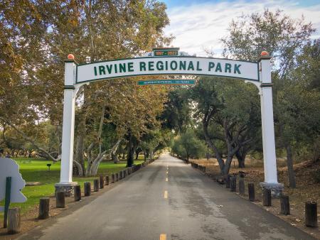
Irvine Regional Park experiences an increase in visitation throughout September and October, especially on weekends. The park entrance may be impacted and the park could close to vehicle traffic if parking reaches capacity.
If you are planning to visit the Pumpkin Patch, please note reservations are now required for weekends in October.
Overflow parking will be available at Santiago Canyon College, 8045 E. Chapman Ave., Orange, CA on the following weekends:
Saturday, Sept. 13 and Sunday, Sept. 14 (6 a.m. to 9 p.m.)
Saturday, Sept. 20 and Sunday, Sept. 21 (6 a.m. to 9 p.m.)
Saturday, Sept. 27 and Sunday, Sept. 28 (6 a.m. to 9 p.m.)
Saturday, Oct. 4 and Sunday, Oct. 5 (6 a.m. to 9 p.m.)
Saturday, Oct. 11 and Sunday, Oct. 12 (6 a.m. to 9 p.m.)
Saturday, Oct. 18 and Sunday, Oct. 19 (6 a.m. to 9 p.m.)
Saturday, Oct. 25 and Sunday, Oct. 26 (6 a.m. to 9 p.m.)
Santiago Canyon College is approximately a half-mile walk to the park.
Parking is $5 per vehicle at Santiago Canyon College. Overnight parking is not permitted. Vehicles must enter from Newport Blvd.
Permits for special events and shelter reservations will not be issued during this time.
Please note: OC Parks annual passes are not valid for parking at Santiago Canyon College.
Craig Regional Park lake will undergo a lake restoration project beginning in June through Fall 2025.
WHAT:
Lake dredging and bank stabilization will be performed along 600 linear feet of shoreline on the north side of the lake. View a project map.
Partially funded through a Habitat Conservation Grant, the project will increase the lake’s depth following many years of sediment build up from urban runoff and storm flows and restore the surrounding banks using native vegetation to improve long-term stabilization and ecological health.
Shelter 5 and a portion of parking lot G will be closed during dredging to allow for construction access.
The repaired shoreline will remain closed after construction while native vegetation is re-established.
WHEN:
Anticipated Construction Duration: June through Fall 2025
Working Days/Hours: Monday – Friday, 7 a.m. to 4 p.m. Work on Saturdays may be performed.
The construction schedule is tentative and subject to change due to weather and other factors.
(Santa Ana, Calif.) – Celebrate the changing seasons with Spring Into Summer, a new event at the historic Old Orange County Courthouse Saturday, May 31 from 11 a.m. to 3 p.m. Visitors of all ages are invited to enjoy live music and art activities, while also learning about the exciting upcoming summer events and programs across OC Parks.
The free family-friendly event will feature live performances by The Como la Flor Band: A Tribute to Selena and Yari Moré Latin Band, and guests are encouraged to bring their blankets and chairs to set out on the Courthouse lawn.
"I am excited to invite the community to join this celebration that will include live music, art and history. Spring Into Summer welcomes all to enjoy an afternoon of fun and entertainment,” said Second District Supervisor Vicente Sarmiento. “Free admission and parking allow residents from near and far to attend, become more familiar with the many summer programs offered by OC Parks, and will also highlight Orange County’s Historic Courthouse, a cherished Santa Ana landmark.”
Spring Into Summer will offer a variety of free activities suitable for all ages, including engaging booths, craft workshops and more. Attendees can also explore the Backyard Kingdom: Orange County’s Natural World exhibit in the Third Floor Gallery, highlighting Orange County’s diverse ecosystems. Additional sketch drawing demonstrations will be available for artists of all levels, as well as a paleontology booth, offering a fascinating look at the region's rich history. Families can also experience fun, new interpretive activities designed to inspire young adventurers to explore the outdoors.
Join OC Parks at Spring Into Summer for a memorable experience filled with learning and fun. The event will feature food trucks on-site with tasty treats available for purchase. Admission and parking are free.
May 31 - Spring Into Summer Time: 11 a.m. - 3 p.m. Admission: Free Location: Old Orange County Courthouse, 211 W Santa Ana Blvd, Santa Ana, CA 92701 Parking: Free event parking available at P8/Transit Tower Parking Structure located at 301 W. 5th St., Santa Ana, CA 92701. Contact: (949) 923-2230
###
OC Parks
OC Parks manages nearly 60,000 acres of parks, historical and coastal facilities and open space for the County of Orange as part of OC Community Resources. http://www.ocparks.com
This project has been completed as of May 14, 2025.
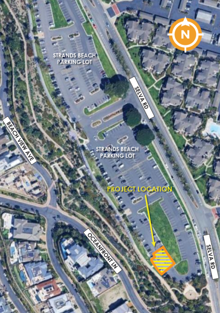
OC Public Works, in collaboration with OC Parks, will be removing and reconstructing a portion of the Strands Beach parking lot in Dana Point. Selva Road will remain open at all times during construction.
WHERE:
South side of the Strands Beach parking lot within the City of Dana Point.
WHAT:
Construction activity on the south side of the Strands Beach parking lot will include removing and reconstructing asphalt concrete, and restriping parking stalls.
Important information:
Access to some parking areas will be temporarily unavailable or limited as the asphalt repair is being performed and new stripes are painted.
Portions of the south side of the parking lot will be used for staging equipment.
The majority of the lot will remain open for public use during construction.
Traffic control measures, such as construction signage and flag personnel will be present.
Please observe all safety signs, barriers and personnel when near the project area.
WHEN:
Anticipated Construction Duration: May 12 - May 22, 2025
Working Days/Hours: Monday - Friday, 7 a.m. - 4 p.m.
The construction schedule is tentative and subject to change due to weather and other factors.
OC Public Works will perform maintenance repairs along the Santa Ana River Trail.
WHAT:
The Santa Ana River Trail will remain open during maintenance.
Work will begin on the existing Santa Ana River Trail between Yorba Linda Blvd./La Palma Ave. to Lincoln Ave.
Work will include removal and replacement of damaged sections of asphalt concrete trail, crack sealing, application of surface seal and re-establishing striping and stenciling.
Traffic control measures such as flag personnel, changeable message signs and extensive delineation of the work area will be present and moved daily to accommodate the work area.
WHEN:
Anticipated Construction Duration: May 5, 2025 - June 2025
Working Days/Hours: Monday - Friday, 7 a.m. - 4 p.m.
The construction schedule is tentative and subject to change due to weather and other factors.
CONTACT INFORMATION:
Construction Inspector Raul Castaneda 714-936-5753
Sup. Construction Inspector Michael Estrada 714-719-1679
(Lake Forest, Calif.)-Discover the rich history of Orange County’s rancho era at the annual Rancho Days Fiesta on Saturday, May 3 from 11 a.m. to 3 p.m. at Heritage Hill Historical Park. This event celebrates the unique history of rancho and Native American cultures through interactive activities, live music, dance performances and more.
Free to attend and fun for all ages, Rancho Days Fiesta features a variety of activities including engaging exhibits, cultural performances, craft workshops, piñata breaking and more. Attendees will enjoy vibrant Folklórico and Native American dances, witness educational Charro horseback riding and roping demonstrations and explore the historic buildings at Heritage Hill Historical Park with guided tours provided by Amigos de la Colina volunteer docents. Pets are welcome in outdoor areas only and must remain on a leash no longer than 6 feet.
“We are thrilled to welcome visitors of all ages to celebrate Rancho Days Fiesta and learn about Orange County’s storied past,” said Supervisor Donald P. Wagner, Orange County Board of Supervisors. “The County of Orange is dedicated to preserving this important legacy and we invite the community to celebrate its rich history together at Rancho Days Fiesta. ”
Heritage Hill Historical Park spans 4.1 acres and includes four fully restored and furnished historic buildings that span the early history of the Saddleback Valley and El Toro area from the Mexican Rancho era to the founding of the town of El Toro through the citrus farming days of the early 20th century. Join OC Parks at Rancho Days Fiesta to experience the charm and excitement of the rancho era.
May 3 - Rancho Days Fiesta Time: 11 a.m. - 3 p.m. Admission: Free Parking: Free Location: Heritage Hill Historical Park, 25151 Serrano Road, Lake Forest, CA 92630 Contact: (949) 923-2230
###
OC Parks
OC Parks manages nearly 60,000 acres of parks, historical and coastal facilities and open space for the County of Orange as part of OC Community Resources.http://www.ocparks.com