
Content block block-countyoc-docaccessscript

Body

Content block block-countyblocksalert--2

Alert: replacereplace

Content block block-views-block-site-alert-alert-site-block-1--2

Select a language:
Orange County Government Logo -- OC Home
Facebook Created with Sketch. Twitter Created with Sketch. Instagram Youtube Created with Sketch.
OC Parks Logo -- Home
  • Alerts
  • Parks & Trails
    • ALERTS
    • Aliso and Wood Canyons Wilderness Park
    • Carbon Canyon Regional Park
    • Featherly Regional Park
    • Harriett M. Wieder Regional Park
    • Irvine Lake
    • Irvine Ranch Open Space
    • Irvine Regional Park
    • Laguna Coast Wilderness Park
    • Laguna Niguel Regional Park
    • Mile Square Regional Park
    • O'Neill Regional Park
    • Peters Canyon Regional Park
    • Ralph B. Clark Regional Park
    • Regional Trails
    • Ronald W. Caspers Wilderness Park
    • Santiago Oaks Regional Park
    • Talbert Regional Park
    • Ted Craig Regional Park
    • Thomas F. Riley Wilderness Park
    • Tri-City Regional Park
    • Upper Newport Bay Nature Preserve
    • Whiting Ranch Wilderness Park
    • William R. Mason Regional Park
    • Yorba Regional Park
  • Beaches
    • Bayside Beach/Newport Harbor
    • Capistrano Beach
    • Dana Point Harbor
    • Salt Creek Beach
    • Sunset Harbour
  • Historic Sites
    • Arden: Helena Modjeska Historic House and Gardens
    • County of Orange Paleontology and Archaeology Collections
    • George Key Ranch Historic Park
    • Heritage Hill Historical Park
    • Historic Yorba Cemetery
    • Irvine Ranch Historic Park
    • Old Orange County Courthouse
    • Ramon Peralta Adobe Historic Site
  • OC Zoo
  • Reservations & Permits
    • Weddings, Parties & Meetings
      • Meetings & Conferences
      • Receptions & Weddings
    • Make a Reservation
      • Reservations FAQs
    • OC Parks Permits
      • Filming & Photography
      • Special Events
        • Vendors With Verified Insurance
      • Group Instruction Permits
      • OC Parks Permits FAQ
      • Land Use Permits
      • Research & Monitoring
      • Newport Harbor Tidelands and Docks
  • About Us
    • Awards and Accolades
    • Commissions and Committees
      • Coastal Greenbelt Authority
      • OC Historical Commission
      • OC Parks Commission
      • OC Parks Trails Subcommittee
    • OC Parks Fees
      • Camping Fees
      • Group Fees
      • Purchase A Pass
        • Annual Pass FAQs
    • OC Parks Jr. Ranger Program
      • Participating Facilities
      • Jr. Ranger Program Resources
      • Jr. Ranger Activities
      • FAQ
    • OC Parks Strategic Plan
      • 2007 Strategic Plan
    • Park Rules
      • Camping Park Rules
      • Regional Park Rules
    • Projects
      • Capistrano Beach Park Master Plan
      • Capistrano-Doheny Beach Nature-Based Shoreline Adaptation Project
      • Craig Park Bike Facility
      • Crawford Canyon
      • Mile Square Park Expansion
      • OC Loop
      • OC Zoo Improvements
      • Peters Canyon GDP
      • Saddleback Gateway
      • South Orange County Regional Coastal Resilience Strategic Plan
      • Sustainability
      • Trail Use Designation Pilot Project
      • Talbert Regional Park Master Plan
    • Volunteer
      • OC Parks Volunteers
      • Orange County Fire Watch
      • Partners
      • Ranger Reserves
      • Short Term Volunteers
      • Internships
      • OC Parks Volunteer Resources
    • Work for OC Parks
    • eNews
      • Newsletter Archive
  • How Do I
    • Apply for...
      • A Film Permit
      • A Job
      • A Permit for a Party
    • Contact...
      • OC Parks
    • Get Involved...
    • Learn More About...
      • Fees
      • OC Parks Jr. Ranger Program
      • OC Parks' Commissions and Committees
      • Programs on the Irvine Ranch Open Space
    • Locate...
      • A Public Record
      • A meeting location
      • A wedding location
      • Park events and programs
    • Purchase...
      • An annual parks / beach pass
    • Rent...
      • A campground
      • A facility for my special occasion
      • A picnic shelter or group area
    • View...
      • Coastal Greenbelt Authority agendas
      • OC Historical Commission agendas
      • OC Parks Commission agendas
      • Trails Subcommittee agendas
Search

Content block block-countyoc-breadcrumbs

Breadcrumb

  1. Home

Content block block-countyoc-page-title

Content block block-countyoc-content

Laguna Niguel Lake Fish Die Off

July 23, 2025
Image
Laguna Niguel
LANI Fish.jpg
Body

Friday, August 29, 2025: OC Parks has received the results of the necropsies performed on three bass fish that died during the incident. Bacteriology, histology, parasitology, heavy metals and viral hemorrhagic septicemia virus (VHSV) were tested. The testing yielded the following results: 

  • Bacteriology: No significant issues detected. 

  • Histology: Results were normal and showed no cause for concern. 

  • Parasitology: No notable parasitic presence identified. 

  • Heavy Metals: Some elevated levels were detected (notably cadmium and arsenic), but not at concentrations high enough to explain the mortality of approximately 500 fish. It is important to note that heavy metals (such as mercury, cadmium, copper, etc.) tend to persist in tissues over time. 

  • Viral hemorrhagic septicemia virus (VHSV): Not detected. 

View the full necropsy report. 

Following this incident, OC Parks is taking steps to have the necessary equipment and resources in place to be more prepared and respond quicker should anything like this occur in the future. Inspection protocols are being thoroughly reviewed to identify where improvements can be implemented to minimize downtime and prevent future equipment failures. This includes increasing the frequency of inspections for critical components like manifolds and aerators and creating a preventative maintenance schedule.  Additionally, remote lake monitoring options are being explored which will give better insights into changing lake conditions, allowing for a more proactive response. 

For additional information related to this incident, visit FAQs.


Friday, August 8, 2025: OC Parks has completed a thorough analysis and review of multiple water samples collected throughout Laguna Niguel Lake and Sulphur Creek. No substances of significant level of concern were detected and healthy water qualities were observed. The results further add to the hypothesis that the fish die off incident most likely occurred naturally due to changing weather conditions throughout July. 

Image
WaterSampling_compressed
WaterSampling_compressed.jpg

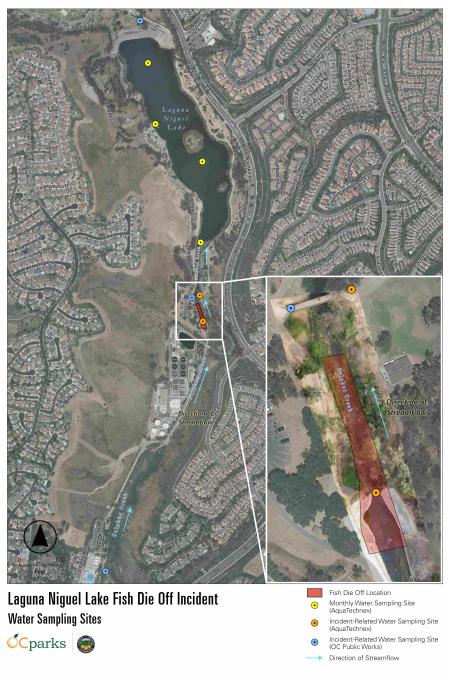
Water sampling sites in Laguna Niguel Lake and Sulphur Creek. Click to view image.  

During the summer months, phytoplankton (microscopic photosynthesizing algae) naturally occur in larger numbers. These organisms may bloom into sizable populations in warm weather when there is prolonged sunlight and little cloud cover. When this happens, phytoplankton will photosynthesize during the day, which can increase concentrations of dissolved oxygen in water, critical for fish survival. After sunset, phytoplankton and other plants in the lake ecosystem consume oxygen, causing dissolved oxygen concentrations in the water to fall. 

When there is heavy cloud cover during the day, there may not be enough sunlight to sustain the phytoplankton bloom. This can lead to lower dissolved oxygen levels or a crash in the phytoplankton population. The drastic change can deplete dissolved oxygen and threaten fish and other organisms in the lake. 

The graph below shows July 2025 cloud cover data for Laguna Niguel. The data reveals little cloud cover in mid-July. The low cloud cover was immediately followed by high cloud cover for the next several days, ranging from 82% to 100% coverage. Experts believe this change likely reduced photosynthesis and dissolved oxygen production within the lake, causing this low oxygen event. While it is not believed to have had an effect on this incident, six aerators were also offline at the time, which could have impacted the conditions in the lake. 

Image
Cloud Coverage
Cloud Coverage (1) (1).png

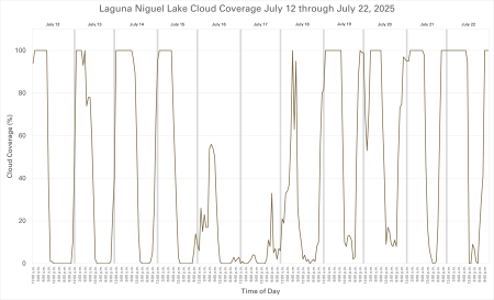
Laguna Niguel Lake cloud coverage July 12 – 22, 2025. Click to view image. 

In these low oxygen conditions, fish in the lake likely would have sought areas with more oxygen, such as the incoming cooler water upstream in Sulphur Creek or near the Oxygen Saturation Technology Systems (OSTs) that were installed in the deep-water section of the lake in December 2024. Unfortunately, too many fish gathered in the creek at the location where the die off incident occurred. This could have been caused by a combination of factors including the shallow water depths in that area or insufficient dissolved oxygen for the number of fish that were in such a small area. 

To ensure a thorough analysis of all possible factors that may have contributed to the die off incident, OC Parks worked closely with OC Public Works to collect water samples in three locations within Sulphur Creek, which is primarily fed by urban runoff. Samples were analyzed for nutrient content, water quality and several major classes of pesticides and metals. Healthy water quality levels were observed, and the findings concluded a toxic event likely did not cause the fish die off. 

Water samples analyzed for ph levels, water temperature, nutrients and solids yielded results within normal range. View the full nutrients report. 

Dinetofuran and thiamethoxam, two neonicotinoid pesticides, were detected in Sulphur Creek at levels far below scientific benchmarks from the U.S. Enviornmental Protection Agency (USEPA 2023)1 and published studies (Finnegan et al. 2017)2. 

An herbicide, glyphosate, was detected in one of three water samples collected from the creek at a very low concentration, just above the method detection limit. This particular water sample was collected outside the boundaries of Laguna Niguel Regional Park at a concentration far below the lowest toxic concentration. View the full pesticides report. 

Concentrations of metals were below levels of concern as compared to thresholds in the California Toxics Rule. View the full metals report. 

OC Parks is awaiting the results of the necropsy. Once received, further information will be shared. 

1 USEPA. 2023. Dinetofuran DRAFT Biological Evaluation: Effects determinations for federally listed endangered and threatened species and designated critical habitats. Environmental Fate and Effects Division, Office of Pesticide Programs, USEPA, Washington, DC. 

2 Finnegan, M.C., L.R. Baxter, J.D Maul, M.L. Hanson, and P.F. Hoekstra. 2017. Comprehensive characterization of the acute and chronic toxicity of the neonicotinoid insecticide thiamethoxam to a suite of aquatic primary producers, invertebrates, and fish. Environ. Toxicol. Chem. 2017 Oct;36(10): 2838-2848. 


Friday, August 1, 2025: A Town Hall meeting to discuss the fish die off will take place Saturday, August 9 from 10 a.m. to 12 p.m. at Laguna Niguel Regional Park. More information and register for the Town Hall.


Wednesday, July 30, 2025: OC Parks has received the results of a hydroacoustic, sonar-based fish mapping survey throughout Laguna Niguel Lake. This high-tech method uses sound waves to assess fish population, distribution and habitat use in the lake. During the survey, sonar equipment emits sound waves into the water and records the echoes that return after bouncing off objects such as fish. The survey illustrates where fish are actively present within the lake and shows evidence of a healthy and sustained fish population. 

As shown below, the map indicates the density and distribution of fish in Laguna Niguel Lake. The numbers and contour lines represent the approximate water depth, and the brightest color yellow represents the presence of 10 or more fish within the zone.  

Mapping shows the highest population density of fish are concentrated in the north end of the lake where the water is deeper and cooler. This is also where two oxygen saturation systems (OST) are located, which saturate the water with dissolved oxygen and are most effective when used in deep water. Please note, hydroacoustic mapping software does not show fish populations in water less than 3 feet deep, therefore fish in the shallower, south end of the lake may not be represented on this map. However, this mapping does provide a comprehensive look at fish abundance and distribution throughout Laguna Niguel Lake. 

Image
Laguna Niguel Lake Hydroacoustic Map
Laguna Niguel Lake Hydroacoustic Map.png

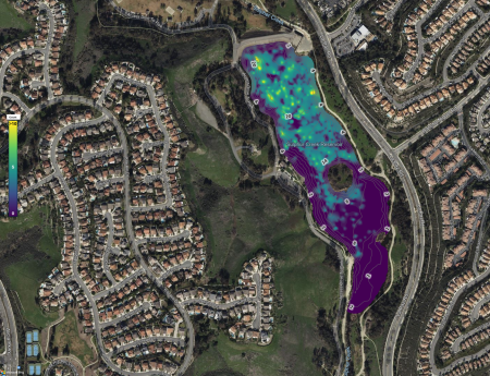
Hydroacoustic mapping completed Monday, July 28, 2025. Click map to access the document. 


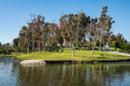
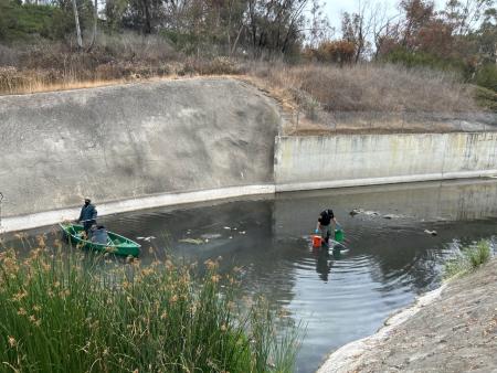
Friday, July 25, 2025: As of Thursday, July 24, all cleanup efforts from the recent fish die off within Sulphur Creek near the south end of Laguna Niguel Lake have concluded. Approximately 500 fish were affected, predominantly bass and bluegill, and there have been no reports of additional fish surfacing.  

OC Parks continues to work closely with experts in the field to monitor the current conditions of the lake. Water samples from multiple locations and depths have been collected to test water quality, including temperature, dissolved oxygen (DO), pH, and conductivity (salinity). Hydroacoustic fish mapping is also being conducted to assess the remaining fish population in Laguna Niguel Lake. 

Image
Laguna Niguel Map
Laguna Niguel Fish Die Off.jpg

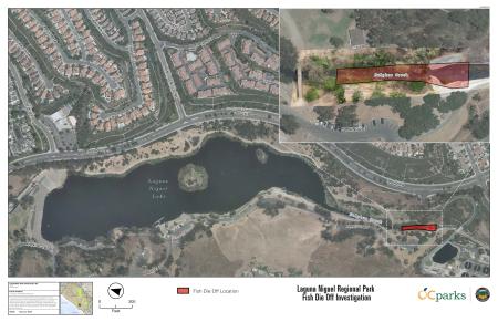
Location of fish die off within Laguna Niguel Regional Park. Click map to access the document. 


Wednesday, July 23, 2025: OC Parks is saddened by the recent fish die off that occurred at Laguna Niguel Lake within Laguna Niguel Regional Park and have been working around the clock to address the situation. We understand the importance these lakes have for the community and want to stress that we are taking this very seriously.  

While we cannot definitively say exactly what caused this to happen, as fish die offs can occur naturally from time to time, a combination of factors could have contributed to the situation such as changing weather, increase in water temperature, a lower than average rainfall year, the presence of algae and potential equipment malfunction.  

As of now, it appears the fish die off was due to a change in weather causing the water temperature to increase, particularly in the shallow waters at the south end of the lake where most of the fish were seen on the surface. When this happens, there is less oxygen in the water, which is critical to fish survival. Catfish can tolerate the warmer, desert-like conditions present in Laguna Niguel Lake this time of year, but other fish are more affected, seemingly leading to this fish die off. While there is no way to control the water temperature of the lake, further steps are being taken that could possibly help mitigate this from occurring in the future. 

OC Parks cares deeply about providing the necessary conditions for fish to survive and thrive in the lakes under our management. All equipment has been thoroughly checked to certify everything is functioning properly. Additionally, we are continuing to monitor water temperature and oxygen levels within the lake to ensure conditions remain stable.  

As of Wednesday, July 23, most of the cleanup efforts have concluded, with only a handful of fish surfacing over the last 24 hours. When visiting Laguna Niguel Regional Park, should you ever encounter any wildlife in distress, please contact the park office at (949) 923-2240. 

Links in this section relate to Body

Halloween Zoo-tacular at the OC Zoo

Body

Join us for Halloween fun at the OC Zoo! Activities include a scavenger hunt*, trick-or-treating*, and spooky crafts for kids!

Come see the zoo animals receive treat-filled pumpkins throughout the day!

Reservations are not needed. Activities are free with paid zoo admission ($2 per person, ages 2 and under are free).

Zoo coupons and free zoo passes are not valid for this event. 

Parking is $5 per vehicle on weekends. 

*Trick-or-treating candy & scavenger hunt prizes available while supplies last.

**Children ages 12 and under.

Image
Image
OC Zoo Halloween 3
IMG_9306 (1).jpg

Aliso Creek Bikeway Slope Repairs

July 23, 2025
Image
Aliso Creek Bikeway Repairs_Phase 1 photo
Aliso Creek Bikeway Repairs_Phase 1 photo.jpg
Body

This project has been completed as of December 2025.

OC Public Works will perform stabilization improvements along a portion of the Aliso Creek Bikeway to address potential erosion and ensure effective flood protection.

WHERE: 

Aliso Creek Bikeway between the I-5 (San Diego Freeway) and Paseo de Valencia.

WHAT: 

A portion of the Aliso Creek Bikeway will be closed intermittently during construction. 

  • Crews will install rock “rip-rap” bank protection and grade stabilization in multiple areas along the Aliso Creek Bikeway. Rip-rap are large rocks placed to minimize erosion.
  • Residents living in close proximity to the flood channel will experience a temporary increase in noise and dust during working hours.
  • A portion of the bikeway will be closed intermittently during construction. Signage will be present and detours will be implemented.
  • There may be brief delays or stops for the public along the trail for vehicles and equipment entering the work area. Flag personnel will be on site to guide people through the area.
  • Drivers will have full access to all surrounding roads, yet may experience brief delays at times during certain project activities.

WHEN: 

Anticipated Construction Duration:
Phase I: July - September 2025
Phase II: September - December 2025

Working Days/Hours:
Monday - Friday, 7 a.m. - 5 p.m.

The construction schedule is tentative and subject to change due to weather and other factors.

CONTACT INFORMATION: 

Sr. Construction Inspector Raul Castaneda
714-936-5753

Sup. Construction Inspector Maria Villafana
714-659-0892

ProjectInfo@ocpw.ocgov.com
ocpublicworks.com 

Links in this section relate to Body

Irvine Regional Park Overflow Parking Information

September 2, 2025
Image
Irvine Regional Park
Irvine Regional Park 125 Sign_2.jpg
Body

Irvine Regional Park experiences an increase in visitation throughout September and October, especially on weekends. The park entrance may be impacted and the park could close to vehicle traffic if parking reaches capacity. 

If you are planning to visit the Pumpkin Patch, please note reservations are now required for weekends in October. 

Overflow parking will be available at Santiago Canyon College, 8045 E. Chapman Ave., Orange, CA on the following weekends: 

  • Saturday, Sept. 13 and Sunday, Sept. 14 (6 a.m. to 9 p.m.)
  • Saturday, Sept. 20 and Sunday, Sept. 21 (6 a.m. to 9 p.m.)
  • Saturday, Sept. 27 and Sunday, Sept. 28 (6 a.m. to 9 p.m.)
  • Saturday, Oct. 4 and Sunday, Oct. 5 (6 a.m. to 9 p.m.)
  • Saturday, Oct. 11 and Sunday, Oct. 12 (6 a.m. to 9 p.m.)
  • Saturday, Oct. 18 and Sunday, Oct. 19 (6 a.m. to 9 p.m.)
  • Saturday, Oct. 25 and Sunday, Oct. 26 (6 a.m. to 9 p.m.)

Santiago Canyon College is approximately a half-mile walk to the park. 

Parking is $5 per vehicle at Santiago Canyon College. Overnight parking is not permitted. Vehicles must enter from Newport Blvd. 

Permits for special events and shelter reservations will not be issued during this time. 

Please note: OC Parks annual passes are not valid for parking at Santiago Canyon College.

Craig Regional Park Lake Restoration Project

May 28, 2025
Image
Craig Regional Park Lake Restoration Project
Craig Regional Park Lake Restoration Project.jpg
Body

Project Summary: 

Craig Regional Park lake will undergo a lake restoration project beginning in June through Fall 2025. 

WHAT: 

  • Lake dredging and bank stabilization will be performed along 600 linear feet of shoreline on the north side of the lake. View a project map.
  • Partially funded through a Habitat Conservation Grant, the project will increase the lake’s depth following many years of sediment build up from urban runoff and storm flows and restore the surrounding banks using native vegetation to improve long-term stabilization and ecological health.
  • Shelter 5 and a portion of parking lot G will be closed during dredging to allow for construction access.
  • The repaired shoreline will remain closed after construction while native vegetation is re-established.

WHEN: 

Anticipated Construction Duration:
June through Fall 2025

Working Days/Hours:
Monday – Friday, 7 a.m. to 4 p.m. Work on Saturdays may be performed. 

The construction schedule is tentative and subject to change due to weather and other factors. 

CONTACT INFORMATION: 
Craig Regional Park 
(714) 973-3180 
craigpark@ocparks.com


Links in this section relate to Body

OC Parks' Spring Into Summer Event Brings Music, Art and Fun to the Old Orange County Courthouse May 31

May 27, 2025
Image
Spring Into Summer
FB Event Photo_SpringIntoSummer_OLCO.jpg
Body

(Santa Ana, Calif.) – Celebrate the changing seasons with Spring Into Summer, a new event at the historic Old Orange County Courthouse Saturday, May 31 from 11 a.m. to 3 p.m. Visitors of all ages are invited to enjoy live music and art activities, while also learning about the exciting upcoming summer events and programs across OC Parks.

The free family-friendly event will feature live performances by The Como la Flor Band: A Tribute to Selena and Yari Moré Latin Band, and guests are encouraged to bring their blankets and chairs to set out on the Courthouse lawn. 

"I am excited to invite the community to join this celebration that will include live music, art and history. Spring Into Summer welcomes all to enjoy an afternoon of fun and entertainment,” said Second District Supervisor Vicente Sarmiento. “Free admission and parking allow residents from near and far to attend, become more familiar with the many summer programs offered by OC Parks, and will also highlight Orange County’s Historic Courthouse, a cherished Santa Ana landmark.”

Spring Into Summer will offer a variety of free activities suitable for all ages, including engaging booths, craft workshops and more. Attendees can also explore the Backyard Kingdom: Orange County’s Natural World exhibit in the Third Floor Gallery, highlighting Orange County’s diverse ecosystems. Additional sketch drawing demonstrations will be available for artists of all levels, as well as a paleontology booth, offering a fascinating look at the region's rich history. Families can also experience fun, new interpretive activities designed to inspire young adventurers to explore the outdoors.

Join OC Parks at Spring Into Summer for a memorable experience filled with learning and fun. The event will feature food trucks on-site with tasty treats available for purchase. Admission and parking are free.

Read this release in:

  • Chinese-Traditional
  • Korean
  • Spanish
  • Vietnamese

May 31 - Spring Into Summer
Time: 11 a.m. - 3 p.m. 
Admission: Free  
Location: Old Orange County Courthouse, 211 W Santa Ana Blvd, Santa Ana, CA 92701
Parking: Free event parking available at P8/Transit Tower Parking Structure located at 301 W. 5th St., Santa Ana, CA 92701.
Contact: (949) 923-2230


###

OC Parks

OC Parks manages nearly 60,000 acres of parks, historical and coastal facilities and open space for the County of Orange as part of OC Community Resources. http://www.ocparks.com

Links in this section relate to Body

Strands Beach Parking Lot Construction

May 9, 2025
Image
Strands Parking Lot
Strands Parking Lot.PNG
Body

This project has been completed as of May 14, 2025. 

OC Public Works, in collaboration with OC Parks, will be removing and reconstructing a portion of the Strands Beach parking lot in Dana Point. Selva Road will remain open at all times during construction.

WHERE:

South side of the Strands Beach parking lot within the City of Dana Point.

WHAT: 

Construction activity on the south side of the Strands Beach parking lot will include removing and reconstructing asphalt concrete, and restriping parking stalls.

Important information: 

  • Access to some parking areas will be temporarily unavailable or limited as the asphalt repair is being performed and new stripes are painted.
  • Portions of the south side of the parking lot will be used for staging equipment.
  • The majority of the lot will remain open for public use during construction.
  • Traffic control measures, such as construction signage and flag personnel will be present.
  • Please observe all safety signs, barriers and personnel when near the project area.

WHEN: 

Anticipated Construction Duration:
May 12 - May 22, 2025

Working Days/Hours:
Monday - Friday, 7 a.m. - 4 p.m.

The construction schedule is tentative and subject to change due to weather and other factors.

CONTACT INFORMATION: 

Mario Barragan
714-448-7746

Raymond Marcial
714-454-7989

ProjectInfo@ocpw.ocgov.com
ocpublicworks.com 

Image
Strands Parking Lot Construction
Strands Parking Lot Construction.PNG
Links in this section relate to Body

Santa Ana River Trail Resurfacing

April 29, 2025
Image
Santa Ana River Trail Improvements
SART Improvements.PNG
Body

OC Public Works will perform maintenance repairs along the Santa Ana River Trail. 

WHAT: 

The Santa Ana River Trail will remain open during maintenance.

  • Work will begin on the existing Santa Ana River Trail between Yorba Linda Blvd./La Palma Ave. to Lincoln Ave.
  • Work will include removal and replacement of damaged sections of asphalt concrete trail, crack sealing, application of surface seal and re-establishing striping and stenciling. 
  • Traffic control measures such as flag personnel, changeable message signs and extensive delineation of the work area will be present and moved daily to accommodate the work area. 

WHEN: 

Anticipated Construction Duration:
May 5, 2025 - June 2025

Working Days/Hours:
Monday - Friday, 7 a.m. - 4 p.m.

The construction schedule is tentative and subject to change due to weather and other factors.

CONTACT INFORMATION: 

Construction Inspector Raul Castaneda
714-936-5753

Sup. Construction Inspector Michael Estrada
714-719-1679

ProjectInfo@ocpw.ocgov.com
ocpublicworks.com 


Links in this section relate to Body

CANCELED: Wilderness Access Day: Saddleback Wilderness

Body

*This program has been canceled due to wet and muddy conditions.*

Access is first come, first served until parking capacity is reached. No registration required.

Equestrians, while space is not guaranteed we encourage you to please email irvineranchopenspace@ocparks.com to coordinate parking.

Come explore 3.3-miles of new trails at Saddleback Wilderness, part of OC Parks’ Irvine Ranch Open Space, through this self-guided opportunity. Designated trails will be open for self-guided hiking, biking and equestrian use. There are multiple trail loop options which vary in distance and level of difficulty. Choices range from an easy 1-mile loop to multiple figure-8 configurations for those looking to maximize their mileage. Regardless of distance, nearly all options feature scenic views including a destination vista point offering 360-degree perspectives from the mountains to the sea.

Please review our Trail Tips page and FAQ page to prepare for your experience in the wilderness area.

Gates will open no earlier than 8 a.m.  Please do not block gate or park on Santiago Canyon Road.

Click here to learn more. 

Saddleback Wilderness is located at 3081 Santiago Canyon Road, Orange, CA, 92869. 

Links in this section relate to Body
Image
Image
Saddleback Wilderness
Saddleback Wilderness_2.jpg

CANCELED: Wilderness Access Day: Saddleback Wilderness

Body

*This program is canceled due to wet and muddy conditions.*

Access is first come, first served until parking capacity is reached. No registration required.

Equestrians, while space is not guaranteed we encourage you to please email irvineranchopenspace@ocparks.com to coordinate parking.

Come explore 3.3-miles of new trails at Saddleback Wilderness, part of OC Parks’ Irvine Ranch Open Space, through this self-guided opportunity. Designated trails will be open for self-guided hiking, biking and equestrian use. There are multiple trail loop options which vary in distance and level of difficulty. Choices range from an easy 1-mile loop to multiple figure-8 configurations for those looking to maximize their mileage. Regardless of distance, nearly all options feature scenic views including a destination vista point offering 360-degree perspectives from the mountains to the sea.

Please review our Trail Tips page and FAQ page to prepare for your experience in the wilderness area.

Gates will open no earlier than 8 a.m.  Please do not block gate or park on Santiago Canyon Road.

Click here to learn more. 

Saddleback Wilderness is located at 3081 Santiago Canyon Road, Orange, CA, 92869. 

Links in this section relate to Body
Image
Image
Lupine at Saddleback Wilderness
Lupine at Saddleback Wilderness.jpg
Read More

Pagination

  • Previous page ‹ Previous
  • …
  • Page 125
  • Page 126
  • Page 127
  • Page 128
  • Current page 129
  • Page 130
  • Page 131
  • Page 132
  • Page 133
  • …
  • Next page Next ›
Subscribe to

Content block block-customjs

Body Links in this section relate to Body
Orange County Government Logo -- OC Home

County Directory Assistance

855.886.5400

Navigation

  • Make a Reservation
  • Plan a Party
  • Purchase an Annual Pass
  • Projects
  • Volunteer

Quick Links

  • Acceptable Use
  • Accessibility
  • Contact the County
  • Disclaimer
  • Sitemap

Resources

  • OC Parks Commission Agendas
  • Historical Commission Agendas
  • Fees
  • Newsletter Signup
  • Public Records Requests
  • OC Parks Strategic Plan
  • Privacy Policy

Follow Us

  • Connect on Facebook
  • Connect on Twitter
  • Connect on Youtube
  • Connect with RSS
  • Connect on Chat
  • Connect on Flickr
  • Connect on Apple
  • Connect on Google

The OCTM

Making Orange County a safe, healthy, and fulfilling place to live, work, and play, today and for generations to come, by providing outstanding, cost-effective regional public services.

Browser Support Notice

This browser is no longer supported and some key features will not work. We strongly recommend using Edge, Chrome 70+, Safari 5.x+ and Firefox 5.x+.

Tuyên bố miễn trừ trách nhiệm

Để tạo sự tiện lợi cho người dùng, trang web của Quận Cam này sử dụng dịch vụ dịch ngôn ngữ miễn phí của Google. Khi nhấp vào nút "Tiếp theo", quý vị hiểu rằng các trang của trang web này sẽ được chuyển sang những ngôn ngữ khác ngoài tiếng Anh. Quận Cam đã cố gắng hết sức để bảo đảm tính chính xác của bản dịch. Tuy nhiên, không có vi tính hóa hay bản dịch tự động nào là hoàn hảo. Ví dụ, máy không hiểu được ngữ cảnh nên không thể diễn đạt trọn vẹn ý nghĩa của văn bản. Ngoài ra, có thể thấy sự khác biệt liên quan đến tiếng địa phương hay sở thích vùng miền. Bên cạnh đó, những hình ảnh có chữ, các tập tin PDF, và các ứng dụng đặc biệt trên trang web này cũng không thể được dịch. Quận Cam không chịu trách nhiệm về các bản dịch do Google cung cấp. Phiên bản gốc của trang web này là bằng tiếng Anh. Trong trường hợp có sự khác biệt giữa bản tiếng Anh của trang web và bản dịch, bản tiếng Anh sẽ được ưu tiên. Khi nhấp vào "Tiếp theo", quý vị hiểu rằng bất kỳ sự khác biệt hoặc bất đồng nào trong bản dịch đều không mang tính ràng buộc và không có hiệu lực pháp lý. Quận Cam không thể bảo đảm tính chính xác của văn bản đã chuyển đổi và không chịu bất kỳ trách nhiệm nào phát sinh từ việc quý vị sử dụng hoặc dựa vào bản dịch do Google cung cấp.

Descargo de responsabilidad

Para la comodidad de los usuarios, este sitio web del Condado de Orange utiliza el servicio gratuito de traducción de idiomas de Google. Al hacer clic en el botón "Siguiente", usted entiende que las páginas de este sitio web se convierten en un idioma distinto del inglés. El Condado de Orange ha hecho todo lo posible para garantizar la exactitud de la traducción. Sin embargo, no existe informatización ni traducción automática perfecta. Por ejemplo, la traducción no tiene en cuenta el contexto y el sistema no puede traducir el significado completo del texto. Además, puede encontrar diferencias relacionadas con los dialectos o preferencias regionales. Tampoco puede traducir gráficos con texto, archivos PDF y aplicaciones especiales en este sitio web. El Condado de Orange no es responsable de la traducción proporcionada por Google. La versión original de este sitio web está disponible en inglés. Si hay alguna discrepancia entre la versión en inglés de este sitio web y la versión traducida, prevalecerá la versión en inglés. Al hacer clic en "Siguiente", entiende que cualquier discrepancia o diferencia en la traducción no es vinculante y no tiene ningún efecto legal. El Condado de Orange no puede garantizar la exactitud del texto convertido y no asume ninguna responsabilidad que pueda derivarse de su uso o confianza en la traducción proporcionada por Google.

면책 조항

사용자의 편의를 위해, 본 오렌지 카운티 웹사이트는 무료 Google 언어 번역 서비스를 사용합니다. "Next"(다음) 버튼을 클릭하면, 본 웹사이트의 페이지가 영어 이외의 언어로 제공됨을 이해하는 것으로 간주됩니다. 오렌지 카운티는 번역의 정확성을 보장하기 위해 모든 노력을 기울였습니다. 그러나, 완벽한 전산화 또는 자동 번역은 없습니다. 예를 들어, 번역은 문맥을 고려하지 않기 때문에 텍스트의 의미를 온전히 번역할 수 없습니다. 또한, 지역 방언 또는 선호도와 관련된 차이점도 발견할 수 있습니다. 또한, 본 웹사이트에서는 텍스트가 포함된 그래픽, PDF 파일, 특수 애플리케이션은 번역할 수 없습니다. 오렌지 카운티는 Google에서 제공하는 번역에 대해 책임을 지지 않습니다. 본 웹사이트의 원래 버전은 영어로 제공됩니다. 본 웹사이트의 영어 버전과 번역 버전 사이에 불일치가 있는 경우 영어 버전이 우선합니다. "Next"(다음)를 클릭하면, 번역의 불일치 또는 불충분한 내용은 구속력이 없으며 법적 효력이 없음을 이해하는 것으로 간주됩니다. 오렌지 카운티는 변환된 텍스트의 정확성을 보장할 수 없으며, 사용자가 Google에서 제공하는 번역을 사용하거나 의존함으로써 발생할 수 있는 어떠한 책임도 지지 않습니다.

免責聲明

為方便使用者使用,本橙縣網站採用了 Google (谷歌) 免費語言翻譯服務。當您點擊「Next」(下一個)按鈕,即表示您了解本網站內容將自動翻譯為非英文語言。橙縣已盡力確保翻譯內容的準確性,但機器或自動翻譯服務無法達到完美。例如,翻譯無法完整呈現語境含義,亦可能無法精確反映原文內容。此外,您可能會發現因地區方言或用語偏好而有所差異。而且,本網站上的圖像文字、PDF 檔案以及特定應用程式內容亦無法透過此翻譯服務轉換。橙縣對 Google (谷歌) 翻譯所提供的翻譯內容不負任何責任。本網站的原始語言版本為英文。如英文版本與翻譯版本內容有任何不一致之處,應以英文版本為準。當您點擊「Next」(下一個)時,即表示您了解翻譯內容若有任何差異或不一致之處,均不具法律效力,且不具任何約束力。橙縣無法保證翻譯內容的準確性,亦不對因您使用或依賴 Google (谷歌) 翻譯結果而產生的任何後果承擔責任。

سلب مسئولیت

برای راحتی کاربران، وب‌ سایت اورنج کانتی از سرویس ترجمه رایگان گوگل استفاده می‌ کند. با کلیک روی دکمه "بعدی"، شما تأیید می‌کنید که محتوای این وب ‌سایت به زبان‌هایی غیر از انگلیسی ترجمه خواهد شد. اورنج کانتی تمام تلاش خود را برای دقت ترجمه‌ها انجام داده است، اما هیچ سامانه ترجمه ماشینی بدون خطا نیست. به عنوان مثال، این ترجمه‌ها معمولاً به زمینه‌ی متن حساس نیستند و ممکن است نتوانند معنا و مفهوم دقیق را به‌طور کامل منتقل کنند. همچنین ممکن است تفاوت‌هایی ناشی از لهجه‌ها یا ترجیحات منطقه‌ای مشاهده شود. علاوه بر این، امکان ترجمه گرافیک‌های حاوی متن، فایل‌های PDF و برخی برنامه‌های خاص در این وب‌سایت وجود ندارد. اورنج کانتی مسئول ترجمه‌ای که توسط گوگل ارائه می‌شود، نیست. نسخه اصلی این وب‌ سایت به زبان انگلیسی در دسترس است. در صورت وجود هرگونه اختلاف یا مغایرت بین نسخه انگلیسی و نسخه ترجمه‌ شده، نسخه انگلیسی معتبر و ملاک خواهد بود. با کلیک بر روی "بعدی" ، شما تأیید می‌کنید که هرگونه اختلاف یا مغایرت در ترجمه، الزام‌آور نبوده و هیچ‌گونه اثر قانونی ندارد. اورنج کانتی نمی‌ تواند دقت ترجمه ارائه ‌شده توسط گوگل را تضمین کند و هیچ‌ گونه مسئولیتی در قبال استفاده یا استناد شما به این ترجمه را بر عهده نمی‌ گیرد.

إخلاء المسؤولية

لراحة المستخدمين، يستخدم هذا الموقع الإلكتروني التابع لمقاطعة أورانج خدمة الترجمة المجانية من Google. من خلال النقر على زر "التالي"، فإنك تقر بأن صفحات هذا الموقع سيتم عرضها بلغات غير اللغة الإنجليزية. لقد بذلت مقاطعة أورانج أقصى جهد ممكن لضمان دقة الترجمة، إلا أن الترجمة الآلية لا يمكن أن تكون دقيقة بشكل كامل دائمًا. على سبيل المثال، لا تراعي الترجمة الآلية السياق، وقد لا تتمكن من نقل المعنى الكامل للنص الأصلي. بالإضافة إلى ذلك، قد تلاحظ وجود اختلافات تتعلق باللهجات أو التفضيلات الإقليمية. كما أن الترجمة لا تشمل الصور التي تحتوي على نصوص، أو ملفات PDF، أو التطبيقات الخاصة الموجودة على هذا الموقع. لا تتحمل مقاطعة أورانج أي مسؤولية عن الترجمة التي توفرها خدمة Google. النسخة الأصلية من هذا الموقع متاحة باللغة الإنجليزية. وفي حال وجود أي تعارض أو اختلاف بين النسخة الإنجليزية والنسخة المترجمة، تُعتَمد النسخة الإنجليزية. من خلال النقر على "التالي"، فإنك تقر بأن أي تعارض أو اختلاف في الترجمة غير مُلزِم ولا يترتب عليه أي أثر قانوني. ولا تضمن مقاطعة أورانج دقة النص المُترجَم، ولا تتحمل أي مسؤولية قد تنشأ عن استخدامك أو اعتمادك على الترجمة المقدمة من Google.